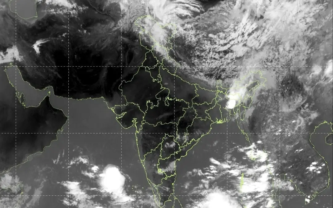
- Yellow Alert Issued: The India Meteorological Department (IMD) has issued a yellow alert for today, Tuesday, May 26, 2026, covering Jammu & Kashmir, Himachal Pradesh, and Uttarakhand.
- The Cause: A “massive” Western Disturbance (WD) is moving across the upper reaches of North India, visible in satellite imagery as a spiral-shaped cloud mass.
- Weather Conditions: Expect light to moderate rain, lightning, and gusty winds reaching speeds of 40–50 kmph.
- Severe Warnings: Isolated areas in Himachal Pradesh and Jammu & Kashmir are on alert for hailstorms and intense vertical thundercloud development.
- Clash of Systems: The unstable weather is caused by the interaction of this cold Western Disturbance with hot pre-monsoon air rising from the plains.
The India Meteorological Department (IMD) has placed several Himalayan states under a yellow alert today, May 26, 2026, as a potent Western Disturbance sweeps across the region. This system is bringing a sharp transition from the recent heatwave conditions to a more unstable, turbulent atmosphere characterized by sudden thunderstorms and localized hailstorms.
Western Disturbance Hits North India
Latest INSAT-3DS satellite imagery shows a dense, cold cloud mass curling over the western Himalayas.
- Regional Impact: Jammu & Kashmir, Himachal Pradesh, and Uttarakhand are the primary states affected. The cloud shields are currently churned over the higher altitudes, indicating significant vertical development.
- Wind & Lightning: The alert warns of gusty winds reaching 50 kmph and frequent lightning strikes, particularly in the afternoons and evenings.
- Hailstorm Risk: Specific pockets in Himachal Pradesh and Jammu & Kashmir have been warned of hailstorms, which could impact standing horticulture and fruit crops in the valley regions.
The Heatwave vs. Thunderstorm Battle
While the mountains see rain, the plains of Northwest and Central India continue to battle severe heatwave conditions.
- Temperature Contrast: High-altitude regions are seeing a temporary dip in mercury, but cities like Delhi and Jaipur are still recording temperatures near 45°C.
- Atmospheric Instability: The “clash” between the scorching dry continental air from the south and the incoming moist system from the north is fueling these violent thunderstorms.
Monsoon Watch: Early Onset Likely
In a separate but related development, the IMD has maintained that the Southwest Monsoon is likely to hit the Kerala coast as early as today or tomorrow (May 26–27).
- Ahead of Schedule: A normal onset usually occurs on June 1. The early arrival is being supported by strengthening westerly winds and a massive cloud surge in the Arabian Sea.
- Pre-Monsoon Activity: This early surge is contributing to the overall moisture in the atmosphere, which is heightening the intensity of the thunderstorms currently being witnessed in the Himalayan states.
Discover more empowering stories and insightful content like this on YOUxTalks, your go-to destination for inspiration and knowledge.
Follow YOUxTalks on Instagram: https://www.instagram.com/youxtalks